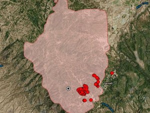
 At the Yarnell Hill Fire: Hotshot crews working in teams of five to seven firefighters under a supervisor used hand-held radios to transmit positions and updates to officials at an incident command center. In recordings of their final calls, though, fire supervisors in aircraft above seemed to struggle to figure out the hotshots’ general location.
The question: The “Yarnell Hill Fire: Serious Accident Investigation Report” in 2013 recommended that the U.S. Forest Service assess whether wildfire crews should be equipped with more sophisticated technology, such as global-positioning satellite trackers.
The big picture:
Elsewhere, the Florida Forest Service is already using GPS tracking on its bulldozers and engines, and the California Department of Forestry and Fire Protection recently began a tracking system using smartphones. Some in the community have asked why the practice isn’t already widespread, given that many smartphone apps already allow users to track one another via GPS.
Where things stand now: The Forest Service, along with NASA’s Jet Propulsion Laboratory, is testing a new system using a grant from the U.S. Department of Homeland Security. Ralph Gonzales, who works in the Forest Service’s Technology and Development Center in San Dimas, Calif., said the project has resulted in five prototype units, which are about the size of a deck of cards or smartphone.
The downside: Software problems, normal wear and tear and limited service coverage in remote areas could cause the units to fail. A crew member cannot afford to fuss with his equipment because it takes away from his “situational awareness,” such as where he is in relation to the flames. Also, the firefighter will be carrying more weight, which means he will travel slower and tire faster.
It’s not as simple as buying a bunch of off-the-shelf GPS units, like the kind seen at REI or Bass Pro Shops, and issuing them to crew members, Gonzales cautioned.
— D.S. Woodfill
Content and images via AZCentral.com
